Generates wetland areas two ways: pulls every National Wetlands Inventory polygon in a picked window from the live USFWS service (planning-level limits, already in the drawing's State Plane grid), or connects the delineator's surveyed flag points into closed boundaries. Closed polylines + hatch + labels + a summary table + CSV. Runs in plain AutoCAD as well as Civil 3D.
What it does
- Run, NWI pull: every USFWS National Wetlands Inventory polygon intersecting the picked window (or the drawing extents), returned already reprojected into the drawing's State Plane WKID (any NAD83 State Plane zone). Each area: closed polylines per ring (islands too), optional hatch (islands excluded as holes; unknown pattern skips with a note), and a label at a guaranteed-interior point, NWI code, plain-English type, and acreage computed from the drawn limits, each toggleable.
- Connect flags: the delineator's surveyed flags become the boundary, COGO points matching a description pattern (
WL*) group by the letter after the prefix and connect in flag order (sequence numbers, falling back to point number), one closed boundary per letter; or pick the points on screen in order (any host). Labels readWETLAND A, (FIELD-DELINEATED), 0.42 AC ±. - Replace-in-place: every entity is stamped with its NWI GLOBALID / flag letter, a re-run replaces that area cleanly, and the funnel prints pages / features / usable / skipped even when nothing comes back.
- Summary table + CSV: area #, source, NWI code, type, drawn acres, and NWI's published whole-polygon acres side by side; the table keeps its user-dragged position across re-runs.
Modes, seats & caveats
- Run / Connect flags / Clear, Clear removes every polyline, hatch, label, and table the tool ever drew.
- Plain AutoCAD: the only Civil 3D API use is the COGO reader, runtime-gated on the host, the NWI pull and pick-points modes fully work on vanilla seats; ships in
VDC.Acad.bundle. - NWI is a screening product: compiled from aerial imagery at inventory scale, boundaries generalized, small/forested/recent wetlands routinely missing, mapped areas can be upland. Absence of NWI polygons never clears a site. Field delineation and USACE / state concurrence establish the limits; every output path says so.
- Flag order is boundary order, a self-crossing loop means out-of-order flags; renumber or use pick mode. With
WLF-1..nflags, useWLF*(withWL*the F reads as a boundary letter). - Network required for the NWI pull; flag modes work offline. Settings at
%APPDATA%\VDC\Wetlands\settings.json(envVDC_WETLANDS_SETTINGS).
Dialog
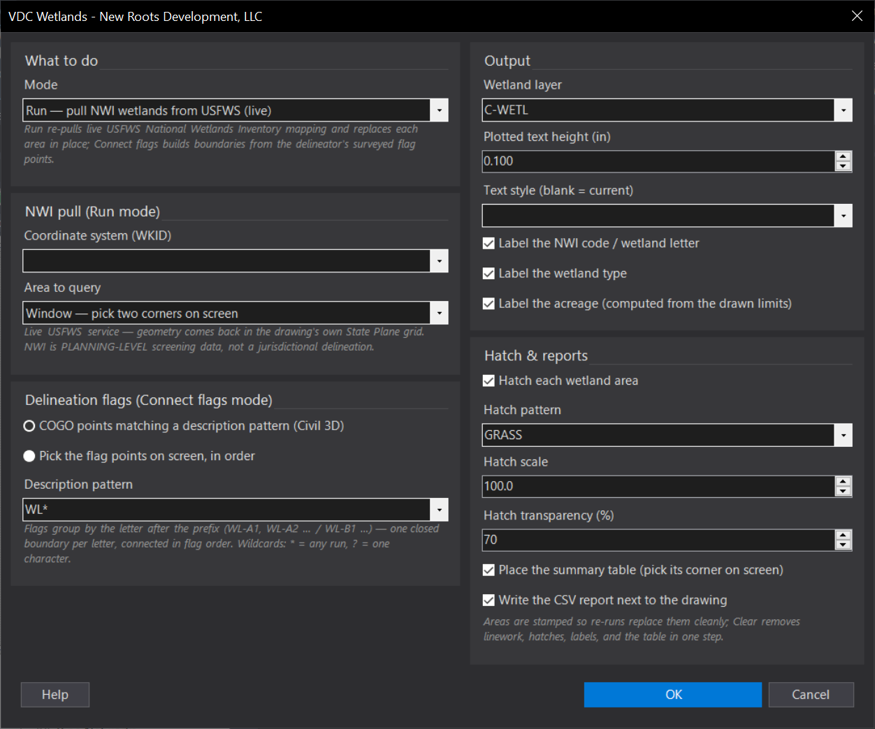
VDCWETLANDWhen to use it
- Due diligence / concept: showing NWI-mapped wetlands on a site before the delineation exists.
- After the delineation: connecting the surveyed flag points into the closed, labeled wetland boundary.
- Permitting exhibits: a hatched, labeled wetland figure with acreage and a summary table in minutes.
How to run it
- Run VDCWETLAND - pick the mode (Run / Connect flags / Clear) and the options; click OK.
- Run mode: pick the two window corners (or nothing for Extents). The tool queries USFWS, prints the funnel (features returned / usable / skipped), and draws.
- Connect flags: matched COGO flags group and connect automatically; in pick mode, click the flags in order and press Enter to close the loop.
- Pick the summary table's corner when prompted (Enter skips it). Review the end-of-run summary.
- Re-run any time - each area is replaced in place by its NWI id / flag letter. Clear removes everything the tool drew.
Options
- Coordinate system (WKID): the drawing's State Plane zone - every NAD83 zone is in the list (262), 2273 SC intl ft, 102733 SC US ft, 2264 NC US ft among them; type any WKID for other zones.
- Area to query: Window (pick two corners - the default) or the drawing extents. A whole-quad pull is never what a site drawing wants.
- Flag source: COGO points matching a description pattern (Civil 3D hosts), or points picked on screen in order (works everywhere, including plain AutoCAD).
- Description pattern: wildcard match on the flag descriptions (WL* default; * = any run, ? = one character). Flags group by the letter after the prefix - WL-A1/WL-A2 vs WL-B1 - one boundary per letter, connected in flag-sequence order.
- Label content: NWI code (PFO1A), plain-English wetland type, and computed acreage (1.23 AC +/-) are each toggleable.
- Hatch: pattern (GRASS default), scale, and transparency; islands hatch as holes. An unknown pattern skips the hatch with a note - the linework still lands.
- Wetland layer / text height / style: where everything lands (default C-WETL, auto-created) and how the labels render.
Watch out for
- NWI is a screening product, NOT a delineation - never let a plan imply otherwise. The drawn limits are planning-grade until a field delineation replaces them.
- Nothing mapped is not nothing there: small, forested, or recently formed wetlands are routinely absent from the NWI. Absence of NWI polygons never clears a site.
- Flag boundaries connect in flag order. A self-crossing boundary means out-of-order flags - renumber them or use pick mode.
- The pattern's prefix matters for grouping: with flags staked WLF-1..n, use WLF* (with WL* the F reads as a boundary letter).
- Network required for the NWI pull - an outage shows a short message and nothing is drawn from stale data. Flag modes work offline.
Related: Flood QC · FIRM Note · Buffer Yard · Tree Table