Labels the subject parcel and every adjoiner: the plat "now-or-formerly" block, from the county's live public GIS parcel service, dropping a formatted MText at each parcel's centroid with PIN / TMS / owner / deed current as of the run.
Subject parcel (your pick)
Shared-boundary adjoiner
Across-road buffer catch
Centroid label anchor
What it does
- Topology: resolves the subject by point-in-polygon from your pick (works over xrefs), then finds every parcel sharing a boundary.
- Buffer catch: parcels within the buffer distance count as adjoiners even without a shared line, across-the-road / across-the-ditch owners.
- Live query: hits the county's public ArcGIS REST service at run time, so PIN / TMS / owner / deed are current, not last-looked-up.
- Placement: one MText per parcel at its centroid, stamped with XData (PIN + profile) so Run/reFresh find and update it in place.
- Name order: reorders
SMITH JOHN AtoJOHN A SMITH; entities (LLC/INC/TRUST),&couples, and ambiguous names stay as published. - Title case (default): the county's ALL-CAPS owner reads
Broadway at the Beach Palace Tract LLC, legal acronyms stay upper. An ALL CAPS toggle forces the whole label upper. - Empty GIS lines drop (a county without deed book/page simply omits that line); PIN/TMS re-masked to plat format.
- Zoning (opt-in): adds a
Zoning: <code>line where the county publishes it, Horry from its separate zoning-district layer (point-in-polygon per parcel), Brunswick off the parcel. Greys out elsewhere; the line collapses when off or blank.
Modes & settings
- Run (default): dialog, then query and place. Match-or-insert by PIN, scoped to the current label layer (+ profile), labels on other layers are invisible to the run, so per-sheet adjoiner sets on separate layers coexist (freeze per viewport; an edge parcel can carry one label per layer). On that layer, with "refresh existing labels" on, matched labels update and parcels dropped from the fresh result are removed; off = additive, add new adjoiners only, leave existing labels untouched so hand-edits survive.
- reFresh (
F): no dialog, re-queries each stamped label by PIN + profile, updates contents in place, no inserts, no deletes. The before-issuing re-verify. - Pick: keep labeling parcels one after another, pick a point inside each, or type PIN at the prompt to enter one; Enter/Esc to finish. The lot-by-lot way to fill out a block. Clear: erases every VDC adjoiner label and boundary polyline.
- Draw parcel boundaries (opt-in): tick the checkbox and each parcel (subject + adjoiners) is also drawn as a closed 2D polyline from the same pull, on the boundary layer you name (default
V-ADJ-PARCEL, ACI 8, auto-created). Re-runs replace a parcel's boundary in place; multipart parcels / holes draw as multiple rings. A reference/coordination line from county mapping, not survey-grade. The sibling commandVDCADJPARCELSdoes boundaries only, no labels (Run / Pick / Clear). - Profiles: Horry County SC, Georgetown County SC, Brunswick County NC, NC OneMap (statewide) built in, each a swappable endpoint + label layout. Add county… (under the county list here and in Adjoiner Parcels, Buffer Yard, Site Data, Site Snapshot) sets up any county with a public ArcGIS parcel layer: paste the layer address, map the fields from dropdowns, Test, Save, kept in
%APPDATA%\VDC\Gis\county-profiles.json. - Label content (all on by default): one checkbox per standard line, PIN / Parcel #, TMS, Owner (header + name drop together), Deed reference. A toggled-off line stays off through Refresh, unlike hand-deleted text (which comes back). Unpublished lines grey out per county; all-off is refused.
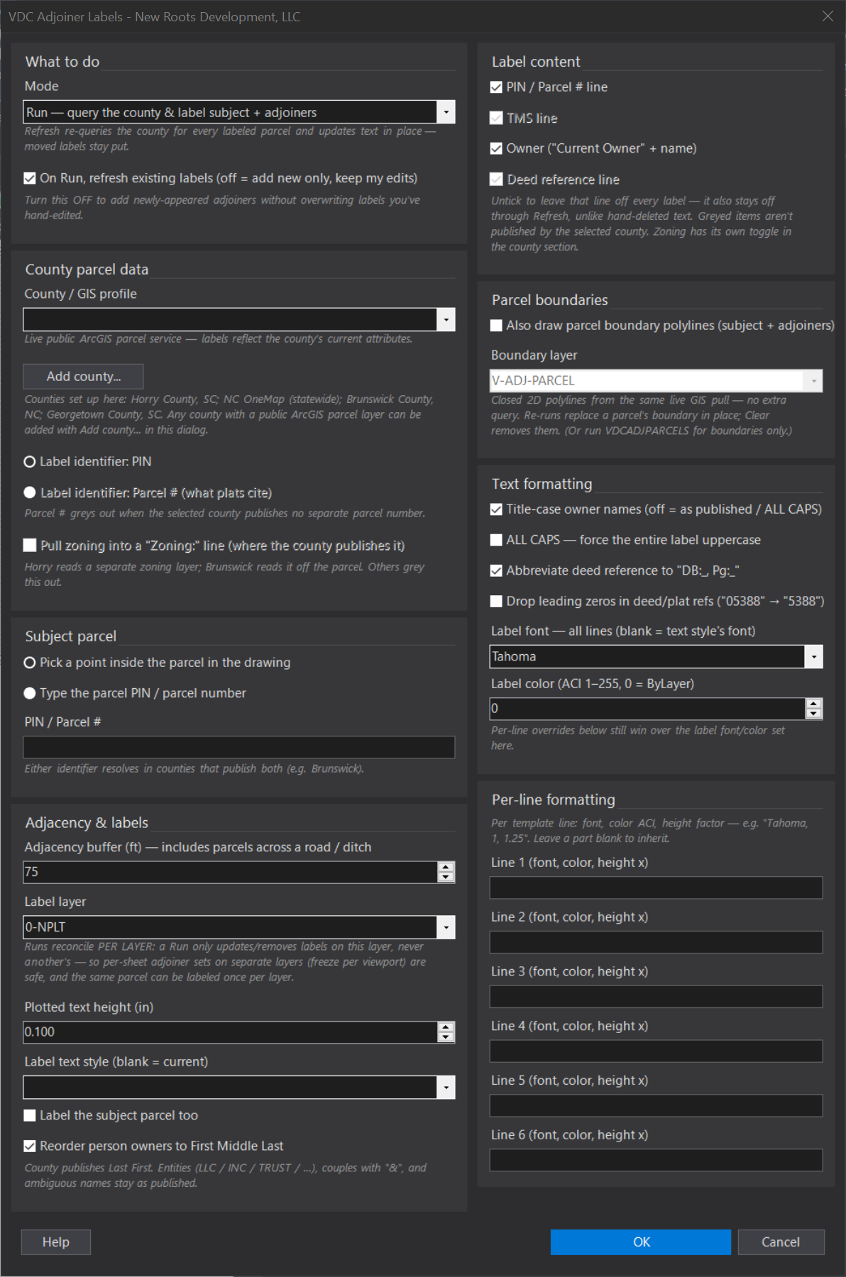
- Dialog: profile, adjoiner buffer (ft), label subject?, pull zoning?, label content checks, refresh existing labels on Run?, label layer (+ auto-create), text height (default 0.1), deed-reference abbreviation (
DB:_, Pg:_), base font (default Tahoma) / color, and per-line font / ACI color / height factor across all six lines. - Settings at
%APPDATA%\VDC\AdjoinerLabels\settings.json(envVDC_ADJLABEL_SETTINGS).
Dialog
VDCADJLABEL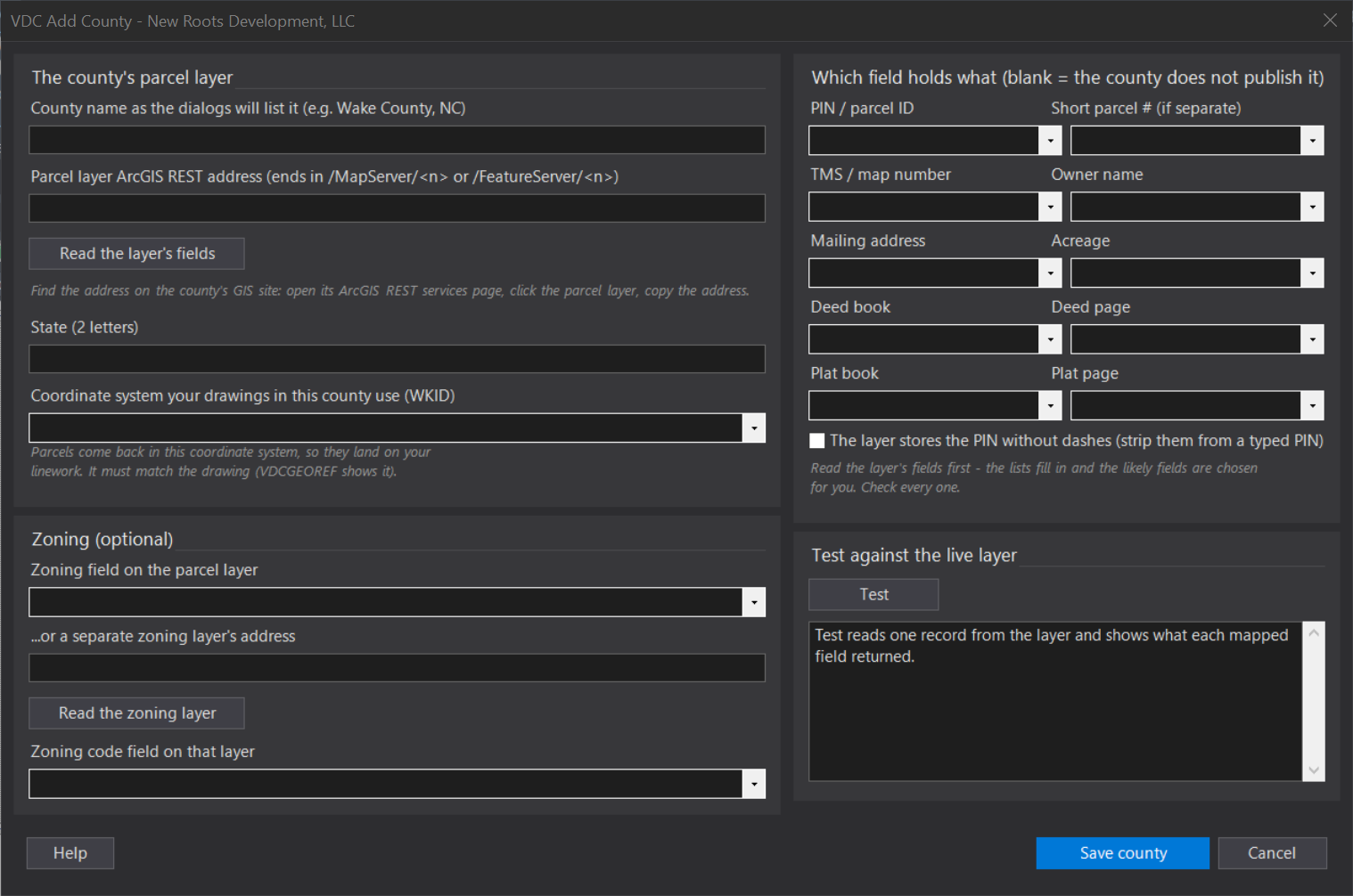
VDCADJLABELWhen to use it
- Building the adjoiner / now-or-formerly block on a plat or exhibit without manual county-site lookups.
- Re-verifying ownership on labels placed weeks ago, right before issuing (reFresh).
How to run it
- Run VDCADJLABEL - the dialog opens with the mode dropdown (Run / Refresh / Pick / Clear); pick the county profile, buffer, label layer, and text height; set the Text formatting options; tick 'Also draw parcel boundary polylines' if you also want the parcel geometry; click OK.
- Pick a point inside the subject parcel - the tool resolves it by point-in-polygon (works over xrefs), queries the county service, and labels the subject plus every adjoiner at its centroid.
- Move labels wherever they read best - re-runs and reFresh update contents in place and respect your positions.
- Before issuing, run VDCADJLABEL in Refresh mode to re-query every label and pull current owner/deed values. Use Pick to keep labeling parcels one after another - pick a point or type PIN at the prompt, Enter/Esc to finish - or Clear to remove all labels.
Options
- County profile: which public GIS service and label layout to use - Horry County SC, Georgetown County SC, Brunswick County NC, or NC OneMap (statewide NC) come built in. Any other county with a public ArcGIS parcel layer is added with the dialog's Add county... button (paste the layer address, map the fields from dropdowns, Test, Save).
- Adjoiner buffer (ft): parcels within this distance of the subject count as adjoiners even without a shared boundary - catches across-the-road and across-the-ditch owners.
- Label subject parcel: whether the subject itself gets a label, or only the adjoiners.
- Label layer / text height: where the MText goes and how tall (default 0.1 in); the layer can be auto-created. Runs reconcile PER LAYER - a Run only updates/removes labels on its own layer, so keep one adjoiner set per sheet on its own layer (freeze the others per viewport) and re-runs never delete another sheet's labels; a shared edge parcel gets a label on EACH sheet's layer.
- Owner-name order: on by default - counties publish SMITH JOHN A; the label renders JOHN A SMITH. Entities (LLC/INC/TRUST), couples with &, and ambiguous names stay as published. A trailing 'et al' (and others) rides at the very end: HENSON ROGER ETAL -> Roger Henson Etal, not Roger Etal Henson.
- Title-case owner names: on by default - the county publishes ALL CAPS; the label reads title case (BROADWAY AT THE BEACH PALACE TRACT LLC -> Broadway at the Beach Palace Tract LLC). Legal acronyms (LLC/INC/LP) stay upper; a name already mixed-case is left alone.
- ALL CAPS: off by default - force the entire label uppercase when a plat style calls for it (wins over title-case).
- Abbreviate deed reference: on by default - the deed line reads DB:_, Pg:_ instead of 'Deed Book _ Deed Page _' (page omitted when the county publishes none).
- Label font / color: one base font for every line (default Tahoma) and a base color (ACI; 0 = ByLayer). Per-line overrides still win.
- Per-line formatting: font, color ACI, and height factor per template line (e.g. Tahoma, 1, 1.25); blank inherits; reFresh re-renders older labels to the current formats. Six adjustable lines, including the zoning line.
- Pull zoning: off by default - adds a 'Zoning: <code>' line from the county's GIS where published. Horry reads a separate zoning-district layer (a point-in-polygon lookup per parcel); Brunswick reads it off the parcel. The checkbox greys out for counties with no zoning, and the line collapses when off or blank.
- Label content: all on by default - one checkbox per standard line: PIN / Parcel #, TMS, Owner ('Current Owner' header + name drop together), and Deed reference. Untick a line to leave it off EVERY label - and unlike hand-deleting the text, a toggled-off line stays off through Refresh. Lines the county doesn't publish grey out; an all-off combination is refused.
- Refresh existing labels on Run: on by default - Run re-pulls and overwrites matched labels and removes orphans. Turn it OFF to ADD newly-appeared adjoiners only while leaving existing labels untouched, so your hand-edits survive a re-run.
- Also draw parcel boundary polylines: off by default - draw each parcel (subject + adjoiners) as a closed 2D polyline from the same GIS pull, on the boundary layer you name (default V-ADJ-PARCEL, ACI 8, auto-created). Re-runs replace a parcel's boundary in place; Clear removes labels AND boundaries. Companion command VDCADJPARCELS does boundaries only, no labels.
Watch out for
- Network required - the queries hit the county's live ArcGIS REST service. An outage or a changed county field schema shows a short message on the command line; nothing is placed from stale data.
- A label line whose GIS fields come back empty is dropped (e.g. a county that doesn't publish deed book/page) - that's by design, not a bug.
- Run mode with 'refresh existing labels' ON removes labels whose parcel dropped out of the fresh result (same profile only) and overwrites matched labels; turn it OFF to add new adjoiners only and keep your edits, or use reFresh for update-in-place with no inserts or deletes.
- You pick a point in the subject parcel - there is NO window step. This tool queries the county service for the subject plus its adjoiners, so a huge (whole-county) drawing is a data question, not a scope one: just pick your lot.
- Parcel boundary polylines are drawn straight from county GIS mapping - a reference/coordination line (typically +/- a few feet), NOT a survey-grade or located boundary. Do not use them where a located boundary is required.
Related: Lot Front · Lot Table · Stake Lots