Drops Civil 3D COGO points at the four lot corners (FL, FR, BL, BR) and the lot centroid (CTR). Shared corners between adjoining lots get combined labels naming both parcels (e.g.
16F/17F, 16B/17B); boundary corners use per-lot Lot N-FL format. Elevation sampled from a reference surface at creation. Auto-deduplicates shared corners within a run and across runs.
Parcel boundary
Corner COGO point (FL/FR/BL/BR)
Centroid COGO point (CTR)
What it does, per lot
- Front-edge pick: click anywhere on the front lot line; xref-nested boundaries supported.
- Topology: front + back + left/right side endpoints resolved via shared
VDC.Common.Civil3D.ParcelHelper. - Side-line adjacency: tool checks each side line for a neighboring parcel, drives the combined-label format below.
- Stake derivation (pure math): FL / FR / BL / BR from topology corners; CTR = vertex centroid (mean of 4).
- Labels: shared corner →
{lower}F/{higher}For{lower}B/{higher}B(lower lot number first,"Lot "prefix stripped). Boundary corner (row endcap or ROW adjacency) → per-lot{LotName}-{Code}. Centroid always per-lot. - COGO insert: each point gets configurable marker style + label style; surface-sampled elevation via
SetElevationBySurface. - Group: appended to
IncludeNumbersquery of the configured group (defaultVDC Lot Stakes, auto-created). - Dedup: tracks placed corners within the run AND pre-seeds with existing group members so re-runs don't stack duplicates at shared corners.
Why this design (Civil 3D 2027)
- Civil 3D 2027 dropped the public API for creating Surface Spot Elevation labels, COGO points + a surface-aware label style is the supported workaround.
- Elevation is stamped at creation; re-run on lots if the surface changes meaningfully.
CogoPointCollection.Addpins marker + label styles as per-point overrides, pick the right styles in the dialog up front.- Tool stamps the point group's defaults on creation so any future user-added points match.
Dialog
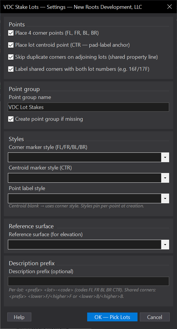
VDCSTAKELOTSSettings file:
%APPDATA%\VDC\StakeLots\settings.jsonWhen to use it
- Preparing a staking point set for the field crew.
How to run it
- Run VDCSTAKELOTS and select the lots.
- Confirm point group / style settings.
- Review the COGO points created at corners and centroids.
Watch out for
- Designate front edges first if you rely on front-corner labeling.
Related: Lot Front · Selecting Parcels · Station-Offset Table