VDCSITESNAPSHOT is part of Site Data (pull public GIS into the drawing); the full section follows.
Everything public about a site, pulled into the drawing in one pick. VDCSITEDATA lists every live public source that applies to the drawing's location: flood, wetlands, soils with hydrologic group, lidar terrain, imagery, hydrography, roads, addresses, buildings, boundaries, zoning, survey control, and lands each checked one on its own layer with labels. VDCSITESNAPSHOT asks the same services what sits under one picked point and hands back the due-diligence sheet.
What it does
- VDCSITEDATA, the pick list: every catalog row that applies to the drawing, national rows + the WKID's state (any NAD83 State Plane zone) + the county profile (Horry / NC OneMap / Brunswick / Georgetown), grouped by category, each reading
[Category] Name → what it becomes. Check all / none / Site basics; checks are remembered per row. - Sources: FEMA flood zones + FIRM panels (BFE lines and cross sections verify); USFWS NWI wetlands; USDA SSURGO map units with hydrologic soil group, drainage class, flooding, hydric %; USGS 3DEP 1 m lidar sampled on a grid → a TIN surface (spacing coarsens automatically to the sample cap); NAIP imagery exported for the window, saved with a world file and attached; NHD streams / waterbodies + the HUC12 watershed; county road centerlines, addresses, footprints, contours (at elevation), soils copies, municipalities, zoning + overlays, airport overlays, future land use, hydrography, flood copies, sanitary districts; SCDOT routes with AADT; NC OneMap centerlines, geodetic control, DWQ-classed streams; NCDOT routes, railroads, municipal boundaries, existing ROW (verify); Census places; HIFLD transmission; FAA runways + airports; USA Structures footprints with heights (optional 3D solids); NGS datasheet marks as COGO points with published heights.
- Runs-next rows: Adjoiner Parcels / Labels, Buffer Yard, Wetlands (full treatment), FIRM, queued after the pull, each with its own dialog.
- Attributes on every entity: every field the service returned lands in a VDC record on the entity and, in Civil 3D, in a property set
VDC_GIS_<SOURCE KEY>, click a parcel, read the owner in the Properties palette's Extended Data tab;VDCGISINFOreads it on any seat. Box in the dialog (default on). The Map 3D Object Data mirror is opt-in (VDC_GIS_OBJECTDATA=1) until a seat proves it clean. - Firm data: Add firm data… puts the firm's own file on the share into the list, a Shapefile / GeoJSON / KML row draws what touches the window; a DWG row attaches the drawing as an xref clipped to the window (live) or copies the entities inside it (editable), with a layer allow-list. Stamped like every row: re-run replaces, Clear removes and detaches.
- Replace-in-place + report: XData stamp per entity (source key + feature id); a re-run replaces that source, Clear removes everything drawn (surfaces + COGO points stay for Prospector). The HTML pull report lists each source's status, counts, layer, and provenance line.
- VDCSITESNAPSHOT: one picked point → parcel (PIN / TMS / owner / mail / deed + plat / acreage / zoning via the county profile), overlays + future land use, flood zone + panel, NWI code, soil map unit + HSG + drainage + flooding + hydric + water table, HUC12, city limits, 3DEP elevation, and the three nearest NGS marks with distance and height. Summary dialog + HTML report + a note at the point; each outage is one unavailable line.
Modes, seats & caveats
- Pull / Clear; area Window (default) / Point + radius / Extents; layer prefix (
GIS-) + each source's own suffix; labels toggle with plotted height + style; terrain surface name (never overwrites), sample spacing, imagery pixels, extrude buildings. - Plain AutoCAD: the only Civil 3D API use is the TIN surface + COGO points, runtime-gated, a vanilla seat gets 3D points and points + labels instead; every other source is identical. Ships in
VDC.Acad.bundle. - Geometry lands in the drawing's grid: ArcGIS layers reproject server-side; soils and NGS (lon/lat) go through the suite's NAD83 state plane transform, verified against NGS NCAT to the millimetre, planning accuracy (datum treated as WGS84, ~1–2 m), not control accuracy.
- Drawn whole, not clipped; paging is automatic and a still-short pull says CAPPED, shrink the window. Imagery needs a saved drawing; if attaching fails the PNG + .pgw are there for IMAGEATTACH.
- Editable catalog:
%APPDATA%\VDC\SiteData\sources.json(envVDC_SITEDATA_SOURCES) overrides by Key, adds rows, or hides built-ins. Settings atsettings.json/snapshot.json(envVDC_SITEDATA_SETTINGS). Endpoints and fields inDATA-SOURCES.md. - Planning-level data. County GIS, FEMA, USFWS, USDA, USGS products at their own scales and dates, every output path carries the draft notice.
Dialog
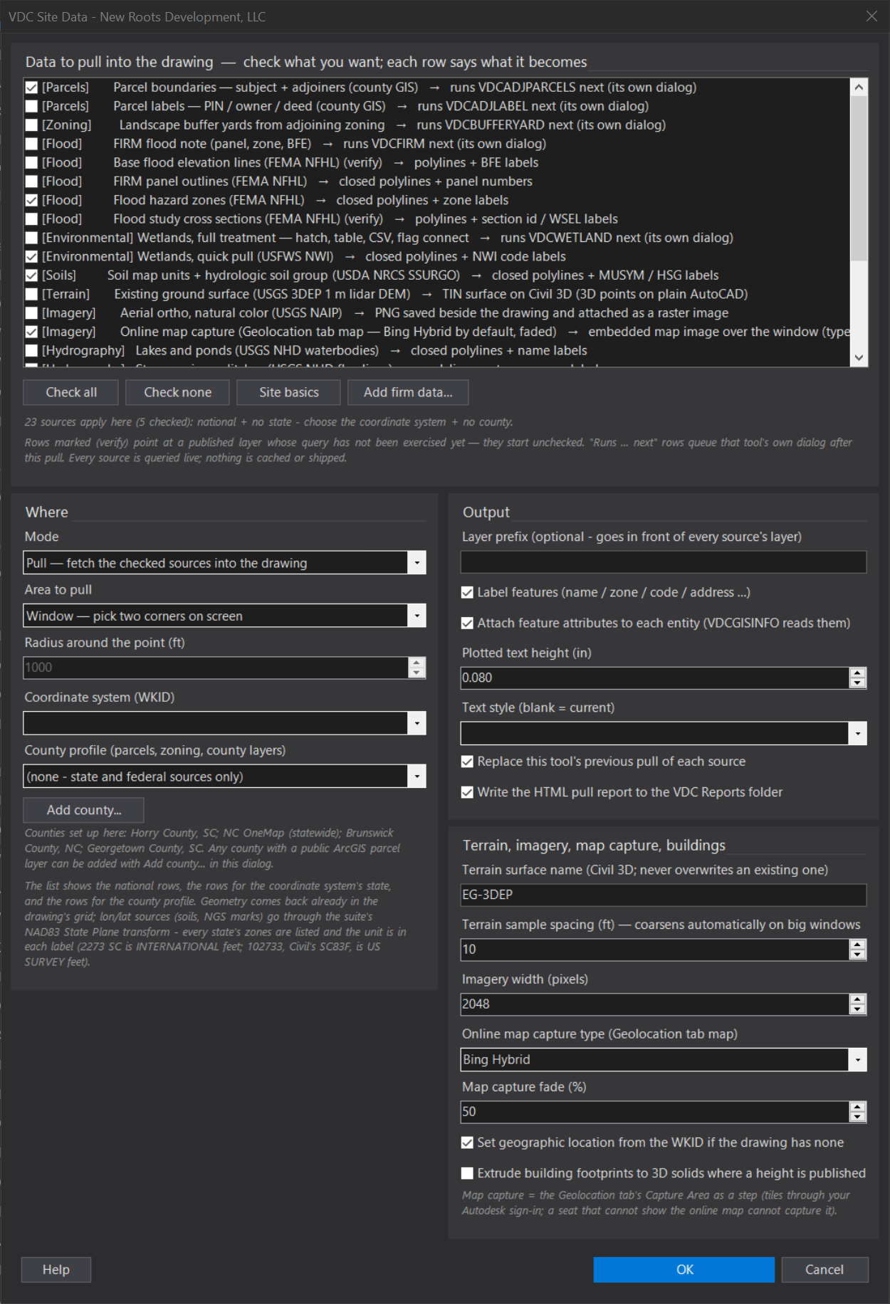
VDCSITEDATA
VDCSITEDATA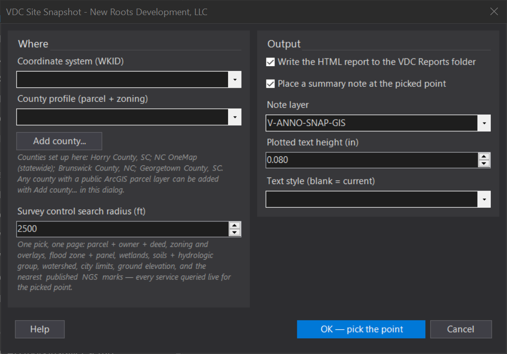
VDCSITESNAPSHOTWhen to use it
- Due diligence / concept: a base map of everything public about a site in minutes, before a survey exists.
- Stormwater design: soil map units with hydrologic soil group and an existing-ground surface from lidar, straight into the drawing.
- Coordination: roads, addresses, city limits, zoning overlays and utilities around the site for exhibits and meetings.
How to run it
- Run VDCSITEDATA - the pick list shows the rows for your WKID's state and county profile; check what to pull (Site basics is the starter set). Set the area, layer prefix, labels, terrain / imagery / building options; click OK.
- Pick the window (or the point) on screen. The status bar walks the sources; each is fetched then drawn in its own transaction.
- Read the summary: per-source feature and entity counts, 'nothing in this window', 'UNAVAILABLE', or 'CAPPED - shrink the window'. The HTML pull report lands in the drawing's VDC Reports folder.
- Any 'runs ... next' rows open their own dialogs after the pull (Adjoiner Parcels, Buffer Yard, Wetlands, FIRM).
- Re-run any time - each checked source is replaced in place. Mode Clear removes everything the tool drew (surfaces and COGO points are left for Prospector).
Options
- Firm data: Add firm data... puts one file on the share into the list - a Shapefile / GeoJSON / KML row draws the features touching the window; a DWG row attaches the drawing as an xref clipped to the window (live) or copies the entities inside it (editable), with a layer allow-list. Rows live in sources.json (VDC_SITEDATA_SOURCES for a shared file).
- Data to pull: the check-list, taller since 1.108.0, with Check all / Check none / Site basics / Add firm data in the row right under it. Checks are remembered per row.
- Area: Window (default), Point + radius (square window at the radius, default 1,000 ft), or Drawing extents.
- Coordinate system / county profile: any NAD83 State Plane zone (262 in the list); Horry / NC OneMap / Brunswick / Georgetown. The list re-filters live and flags a profile that does not match the WKID's state.
- Layer prefix, labels, text height / style: prefix + each source's own suffix; labels are the name / zone / code / address per row, toggleable.
- Replace previous pull: on by default - a re-run of a checked source erases that source's previous entities first.
- Terrain: surface name (never overwrites - suffixed if taken) and sample spacing (default 10 ft; coarsens automatically above 60,000 samples and says so).
- Imagery: width in pixels (default 2048, max 4096); the PNG + .pgw are saved to VDC Reports\Imagery and attached over the window.
- Online map capture: the Geolocation tab's Capture Area as a step - map type (Bing Hybrid default) and fade (50%); the drawing's geographic location is set from the WKID when it has none (SC83F / NC83F, design point at the window center). Tiles come through your Autodesk sign-in, so a seat that cannot show the online map cannot capture it.
- Extrude buildings: footprints with a published height become 3D solids (USA Structures heights are metres, converted; county heights assumed feet).
Watch out for
- Planning-level in, planning-level out. County GIS, FEMA, USFWS, USDA and USGS products never replace a survey, a delineation, a geotech report or a field topo - every output says so.
- Features are drawn whole, not clipped: a lot-sized window still gets the entire watershed polygon that touches it. Pull what you need, freeze what you do not.
- CAPPED means the service stopped short even after paging - shrink the window and re-run for full coverage.
- Imagery needs a saved drawing (the file lives beside it). If attaching fails, the PNG and its .pgw are still there - IMAGEATTACH places it.
- NGS positions come through a planning-grade datum assumption (NAD83 = WGS84, about 1-2 m); use the datasheet values for control work. Heights are converted from metres.
- A county that renumbers a layer breaks that row - re-point it in sources.json (Key + Url) instead of waiting for a release.
- Network required - an outage is one UNAVAILABLE row, never a lost run.
- A DWG row in xref mode re-clips the same attachment on a re-run; a copy-mode row clones only what touches the window, so a bigger window next time brings in more (and the stamp lets Clear take it all out).
- Point rows (addresses, NGS marks, snapshot pins) draw as AutoCAD points shown as a small X (PDMODE 3, PDSIZE -0.5) when the drawing is at the point-style defaults - a PDMODE / PDSIZE you set yourself is left alone.
- The 'runs next' tools (Adjoiner Parcels is ticked by default) queue one at a time after the summary: Cancel in a tool's dialog skips to the next, Esc at a prompt stops the queue. Untick the rows you do not want before OK.
- FEMA refuses VPN exit addresses (the NFHL rows say 'refused the secure connection') - disconnect the VPN for the FEMA sources; the county and USGS services do not care.
- The online map capture needs the seat signed in to Autodesk Account and the Geolocation tab's map able to show in this drawing - the tool switches the map on for the capture; if it still fails the summary names the step.
Related: Site Snapshot · Adjoiner Parcels · Buffer Yard · Wetlands · FIRM Note · Ground Thin