Builds the landscape-ordinance tree preservation / mitigation table from the survey: parses species and DBH out of tree-point descriptions, marks trees inside the limits-of-disturbance polylines as removed, classifies protected vs specimen, and computes the replacement-tree count.
LOD polyline
*LOD*, *DISTURB*, *LIMIT*
Specimen removed (ERROR)
Protected removed (WARNING)
Preserved (outside LOD)
Below threshold
What it does
- Parse: trees are COGO points whose description matches the patterns and parse, first number = DBH inches, remaining words = species (
24 OAK,TREE 30 PINE,36IN LIVE OAK,TR-OAK-18all work). - Removed vs preserved: trees inside any closed polyline on the LOD layers count as removed; the rest preserved.
- Classify: protected (≥ 24" default), specimen (≥ 30"), exempt species list dropped.
- Mitigation:
ceil(removed protected inches × ratio ÷ replacement caliper). - Flags: specimen-in-LOD = ERROR (individual approval), protected-in-LOD = WARNING (mitigation).
- No closed LOD polyline found → every tree reports preserved (command line says so).
Settings & outputs
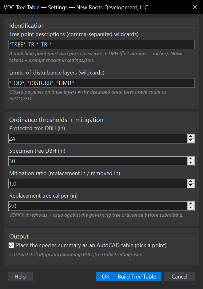
- Tree descriptions: comma wildcards (default
*TREE*, TR *, TR-*); noise tokens (TREE/TR/IN/EX) configurable insettings.json. - LOD layers: default
*LOD*, *DISTURB*, *LIMIT*. - Thresholds + mitigation: protected/specimen DBH, ratio, replacement caliper, verify against the governing ordinance, defaults are placeholders.
- CSV (always): full inventory + per-species summary + mitigation totals.
- AutoCAD table (optional): species summary + mitigation line at a picked point.
- Palette: specimen/protected removals, double-click to zoom. Settings at
%APPDATA%\VDC\TreeTable\settings.json.
Dialog
VDCTREETABLEWhen to use it
- Producing the tree preservation / mitigation table for a landscape or land-disturbance submittal.
- After every grading revision - the LOD moved, the counts moved.
How to run it
- Run VDCTREETABLE; confirm the description patterns, LOD layers, thresholds, and mitigation ratio; click OK.
- The tool parses every matching COGO point, classifies removed vs preserved by the closed LOD polylines, and totals mitigation.
- Pick a point for the species-summary table (or skip); the full inventory CSV lands in the drawing's VDC Reports folder; specimen/protected removals show in the palette.
Options
- Tree descriptions: comma-separated wildcards (default *TREE*, TR *, TR-*); a match must also contain a DBH number.
- LOD layers: closed polylines on these layers are the disturbed area (default *LOD*, *DISTURB*, *LIMIT*).
- Thresholds + mitigation: protected/specimen DBH, replacement inches per removed inch, and replacement caliper - VERIFY against the governing ordinance.
Watch out for
- The default thresholds/ratio are placeholders, not code citations - jurisdictions differ by species class; set them per the ordinance before submitting.
- Specimen removals flag as ERRORS because they typically need individual approval, not just mitigation inches.
- No closed LOD polylines found = every tree reports PRESERVED (the command line says so) - check the LOD layer patterns.
Related: Erosion Control · Quantity Takeoff · Stake Lots