Tallies erosion & sediment-control quantities from objects on the ESC layers: total disturbed acreage, linear items (LF) and count items (EA), and compares the disturbed area to the NPDES permit trigger.
Limits of disturbance / flag
Silt fence (LF)
Tree-protection fence (LF)
Inlet protection (EA)
Construction entrance (EA)
What it does, per run
- Disturbed area: sums closed polylines + hatches on the disturbance layers (e.g.
LOD,LDA,DISTURB), converted to acres. - Linear items: sums silt fence, tree-protection fence, diversion ditch by layer →
LF. - Count items: counts construction entrances, inlet protection by layer →
EA. - NPDES check: compares total disturbed acreage to
NpdesAcreThreshold; at or above it, reports the permit/SWPPP requirement, below it a note to confirm local thresholds. - Layer→item matching is a whole-token match on the layer name (word-boundary, not a raw substring) against each
LayerContainsentry.
Outputs & settings
- CSV:
<drawing> - ESC Quantities.csv, quantity lines plus the NPDES finding; only written when the drawing is saved to a real path. - Palette: findings palette carries the NPDES disturbed-area finding.
- Env var
VDC_ESC_SETTINGS, default%APPDATA%\VDC\Esc\settings.json; schema-tolerant load. - Settings hold the NPDES threshold (default
1.0 ac) and the disturbed / linear / count layer→item maps. - Federal CGP triggers at 1.0 ac; some jurisdictions are stricter, set the threshold for your locale.
Dialog
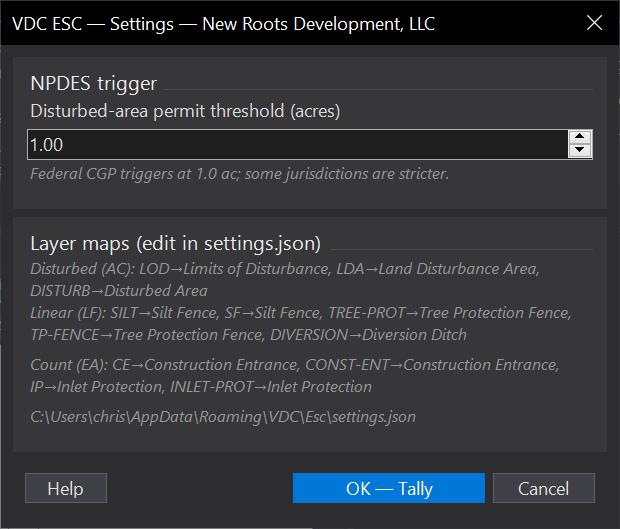
VDCESCWhen to use it
- Building an ESC quantity tally and confirming whether the disturbed area trips the NPDES permit threshold.
How to run it
- Run VDCESC; set the NPDES disturbed-area threshold (default 1.0 ac) and click OK.
- The tool scans the ESC layers for disturbed-area regions, linear items, and count items.
- Read the quantity tally; check the palette for the NPDES disturbed-area finding.
Options
- Disturbed area (AC): from the LOD / LDA / disturbed-area layers; flagged when total >= the threshold.
- Linear (LF): silt fence, tree-protection fence, diversion ditch.
- Counts (EA): construction entrances, inlet protection.
Watch out for
- Federal CGP triggers at 1.0 ac, but some jurisdictions are stricter - set the threshold for your locale.
- Layer-to-item maps live in settings.json; matching is substring-based (e.g. 'SILT' matches any layer containing it).
- The CSV is only written when the drawing is saved to a real path.
Related: Quantity Takeoff · Standards QC · QC Status