
Checks the easements already drawn against the width each pipe reach needs, reads their labels, and reports the worst station of every reach. You declare the public right-of-way and the private streets; the tool never guesses.
Per reach
- Required width from the rule and its depth basis: invert (cover + OD - wall) or bottom of pipe (cover + OD + bedding, GSWSA).
- Cover from a named surface, the pipe's reference surface, or the structure rims - named on every row.
- Public ROW = no easement required; private street = full width; partly in ROW = checked outside only.
- Clearance square to the pipe both ways at every station; centered / edge-clearance rules checked per side. Parallel lines = degraded mode.
- Label: leading width + PUBLIC / PRIVATE; required / drawn / labeled three-way disagreement flagged.
- Stutters (25 / 30 / 25) shown with the run's governing width - never merged.
Results & output
Pass,Fail-Width,Fail-Clearance,Fail-Label,Fail-NoEasement,InROW-NotRequired,Manual-SeeCitation.- Rule confidence on every row; only a confirmed rule gives a REQUIRED width, the rest are recommendations (CSV
WidthStatus, palettereq/rec). - General fallback rules where the jurisdiction's own rule cannot be confirmed: storm 2 x depth + dia + 10, sewer 2 x depth, both rounded up to 5 ft, min 20 ft - "General practice - confirm with the jurisdiction".
<drawing> - Easement Check.csvinVDC Reports(fixed columns for the reviewer) + findings palette.- Temporary markers on non-plotting
VDC-ESMT-CHECK, cleared next run. - Optional candidate bands on
C-ESMT-PROP: straight-sided, squared at the ROW, never parcels. - VDCESMTWIDTH: pick one pipe, see the width math, basis, confidence and citation.
Dialog
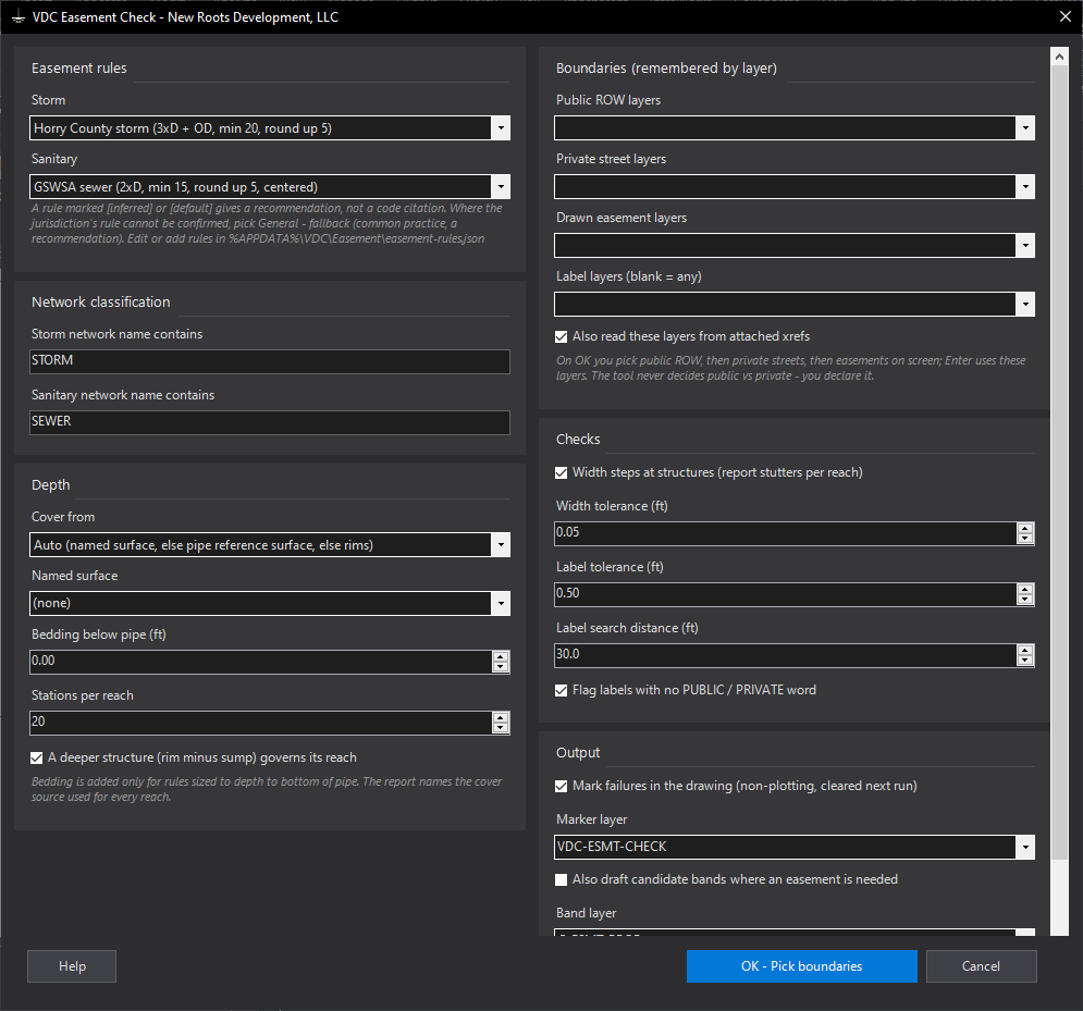
VDCESMTCHECK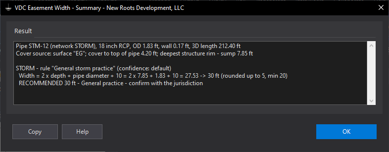
VDCESMTWIDTHSettings file:
%APPDATA%\VDC\Easement\audit-settings.json | %APPDATA%\VDC\Easement\easement-rules.json | %APPDATA%\VDC\Easement\settings.jsonWhen to use it
- Before submittal or plat recordation, on any set with storm or sewer easements.
- When an easement width was carried over from a previous job.
- Inside private streets, where 'the sewer is in the road' still needs an easement.
How to run it
- Run VDCESMTCHECK; pick the storm and sanitary rules (General - fallback where the jurisdiction's own rule cannot be confirmed) and check the network words.
- Choose the area (Enter = whole drawing).
- Pick the public right-of-way boundaries, then the private street boundaries, then the drawn easements (Enter each time = the layers remembered from last time).
- Read the summary, then work the palette rows; double-click zooms to the worst station.
Options
- Cover from: Auto, the pipe's reference surface, a named surface, or the structure rims.
- Bedding: added for rules sized to the bottom of pipe (GSWSA).
- Width steps at structures: off = every reach held to its run's governing width.
- Mark failures: circle + note at the worst station on a non-plotting layer, cleared next run.
- Draft candidate bands: straight-sided bands squared at the public ROW, never parcels.
Watch out for
- Easements drawn as two parallel lines are measured in 'degraded' mode - closed polylines measure best.
- A label is matched to the easement it sits in or points into; a label far from its easement is missed.
- Drafted bands are a drafting aid - verify against the plat before use.
- The CSV's WidthStatus column says Required, Recommended or Recommended - general fallback; the palette writes req or rec before the width.