Samples the proposed surface across closed polygons on the ADA layers: stalls, aisles, landings, and routes, fits a plane to each region, and flags any slope that exceeds the ADAAG limits.
Region within limit
Over-limit (ERROR)
Access aisle polygon
Route (running / cross split)
Grid sample point
Sampled surface
What it does, per run
- Classify: finds closed polygons on the ADA layers, tags each as stall, aisle, landing, or route.
- Sample: reads the chosen surface on a grid at the set spacing plus every polygon vertex.
- Plane fit: least-squares plane over the samples yields the slope gradient, then it is checked.
- Stalls / aisles / landings: steepest slope in any direction must stay under
AnyDirectionMaxPct. - Routes: gradient split on the principal (long) axis,
RouteRunningMaxPctvs.RouteCrossMaxPct. - Thin surface coverage over a region reports a WARNING instead of a pass/fail.
Settings & outputs
- Limits: any-direction
2.0%; route running5.0%/ cross2.0%(defaults). - Sample spacing: grid interval across each region, default
2 ft. - Layers: four editable name lists (stall / aisle / landing / route), must match your annotation or nothing is found.
- Config:
VDC_ADASLOPE_SETTINGS, default%APPDATA%\VDC\AdaSlope\settings.json; schema-tolerant load. - Output:
<drawing> - ADA Slope.csvplus the findings palette (double-click to zoom). - Scope: regions must be closed polygons; bulges read as chords; break L-shaped routes into straight runs.
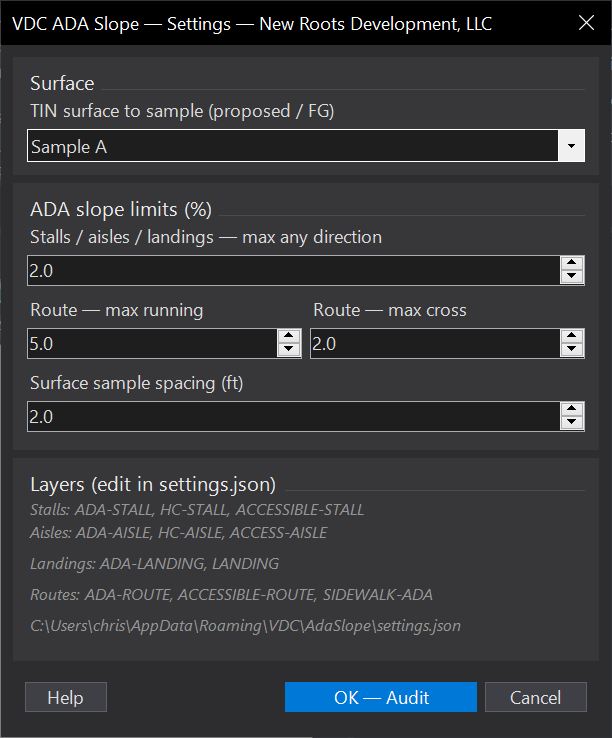
Dialog
VDCADASLOPEWhen to use it
- Checking accessible parking, aisles, landings, and routes for ADA-compliant slopes against the design surface.
How to run it
- Draw the ADA regions as closed polygons on the ADA layers (stalls / aisles / landings / routes).
- Run VDCADASLOPE, pick the surface, and set the slope limits and sample spacing.
- Review the over-limit findings in the palette; double-click a finding to zoom to the region.
Options
- Stalls / aisles / landings: max 2% in any direction (default).
- Routes: max 5% running and 2% cross slope (default).
- Sample spacing: grid interval the surface is sampled at across each region (default 2 ft).
Watch out for
- The ADA layer lists are edited in settings.json (shown as hints in the dialog) - if your layer names differ, nothing is found.
- The regions must be CLOSED polygons on the ADA layers; no closed regions means nothing to sample.
- If the surface is renamed after settings are saved, re-run and re-pick it.
Related: Surface QC · Parking · Road QC