Adds elevation points along feature lines: tangents and curves each at their own spacing (defaults 10 ft / 5 ft), and either type can be turned off. Set the spacing and elevation source once, then pick feature lines one after another, it does not matter which Civil 3D site they are on.
What it does
- Tangents and curves separately: straight runs at one spacing (default 10 ft), arcs at another (default 5 ft), and either type can be turned off to leave those segments alone. Curved segments are detected automatically.
- Spacing restarts at every PI; endpoints and PIs are left alone, they already carry elevations.
- Two elevation sources: interpolate from the feature line (pure densify, geometry unchanged) or sample a surface (drape, reshapes the feature line to it).
- Pick one after another: set it once, then keep picking feature lines; ENTER finishes and all are processed together.
- Any site: feature lines are picked as entities, so site membership is irrelevant.
- Stations computed as
i × increment(not accumulated), so a long segment can't drift. A feature line that can't be segment-mapped falls back to uniform spacing, counted, never silent.
Workflow
- Type
VDCFLPOINTS. - Set the tangent/curve spacing and elevation source (pick the target surface if draping). OK.
- Pick feature lines one at a time, each confirms with a running count. ENTER when done.
- Read the summary: points added on tangents and on curves, stations skipped off-surface, anything Civil 3D rejected.
Settings
%APPDATA%\VDC\FeatureLinePoints\settings.json(envVDC_FLPOINTS_SETTINGS). Tangent/curve on-off + spacing, source, surface persist; an older file's single increment seeds both spacings.
Dialog
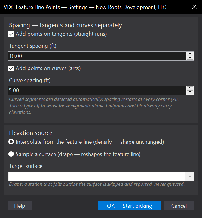
VDCFLPOINTSWhen to use it
- Densifying feature lines before building or refining a surface, so the TIN follows the design instead of long straight spans.
- Curves need denser points than tangents so the arc reads in 3D - set 10 ft tangents / 5 ft curves and run once.
- Draping existing feature lines onto a surface at a regular interval.
- Getting grip-editable elevation points at a consistent spacing for hand grading tweaks.
How to run it
- Run VDCFLPOINTS - the dialog opens: tangent spacing (default 10 ft) and curve spacing (default 5 ft), each with its own on/off, plus the elevation source (interpolate from the feature line, or sample a surface picked from the dropdown). Click OK.
- Pick feature lines one at a time; each pick is confirmed with a running count. Site does not matter.
- Press ENTER when done - every picked feature line is processed in one operation.
- Read the summary dialog: points added on tangents and on curves, stations skipped for falling outside the surface, and anything Civil 3D rejected.
Options
- Add points on tangents + spacing (ft): points on the straight runs between PIs (default 10 ft). Turn off to leave tangents alone.
- Add points on curves + spacing (ft): points on the arc segments (default 5 ft) - curves are detected automatically. Turn off to leave curves alone.
- Interpolate from the feature line: densify only - each point takes the elevation the feature line already has there, so the shape is unchanged.
- Sample a surface: drape - each point takes the chosen surface's elevation at that XY, reshaping the feature line to the surface.
Watch out for
- Points go in at interior stations only, restarting at every PI - endpoints and PIs already carry elevations.
- At least one segment type must be on - the dialog refuses OK with both off.
- Draping: a station that falls outside the surface is skipped and counted, never guessed - check the summary if fewer points landed than expected.
- Sampling a surface RESHAPES the feature line; if you only wanted more points, use Interpolate.
- Feature lines inside an xref cannot be modified - pick host-drawing feature lines (any site is fine).
- A feature line whose geometry cannot be segment-mapped falls back to uniform spacing at the first enabled increment - counted in the summary, never silent.
Related: Feature Line Slopes · Auto-Grade Lots · Refresh All